Welcome to my walking tour of Dumas Bay Wildlife Sanctuary! I aim to share some of the natural history knowledge I've acquired while visiting this natural area. I hope you find it interesting and educational. Enjoy!
Station #1: Land-Use History (magenta)

Before we start walking around too much I'd like to give you a little background knowledge on the history of this park. Prior to 1990, this parcel of land was owned by King County and was untouched. The parcel was turned over to the city of Federal Way when it became incorporated in 1990. Early on, the city decided to keep it as a natural area due to its natural slopes, creeks, wetlands and woodlands that serve as habitat for many species. The land was not altered or restored, but simply preserved as an original natural area. They also figured the area was perfect for a park for the community, as many people enjoy the woodland/wetland/beach variety. It gave people a less busy alternative to the very crowded and popular Dash Point Park located down the street. Surprisingly, this park is actually very low-profile. Many of my friends, despite having lived in this area their whole life, had never heard of it. This is probably a good thing because the wildlife here is
sensitive, and over-use would hinder preservation efforts. Despite being not
very well-known, this park is a great place to practice natural history and see
some cool stuff.
Source (info): Steve Ikerd, Park Deputy of Federal Way
Source (info): Steve Ikerd, Park Deputy of Federal Way
Station #2: Geology/Geomorphology (blue)
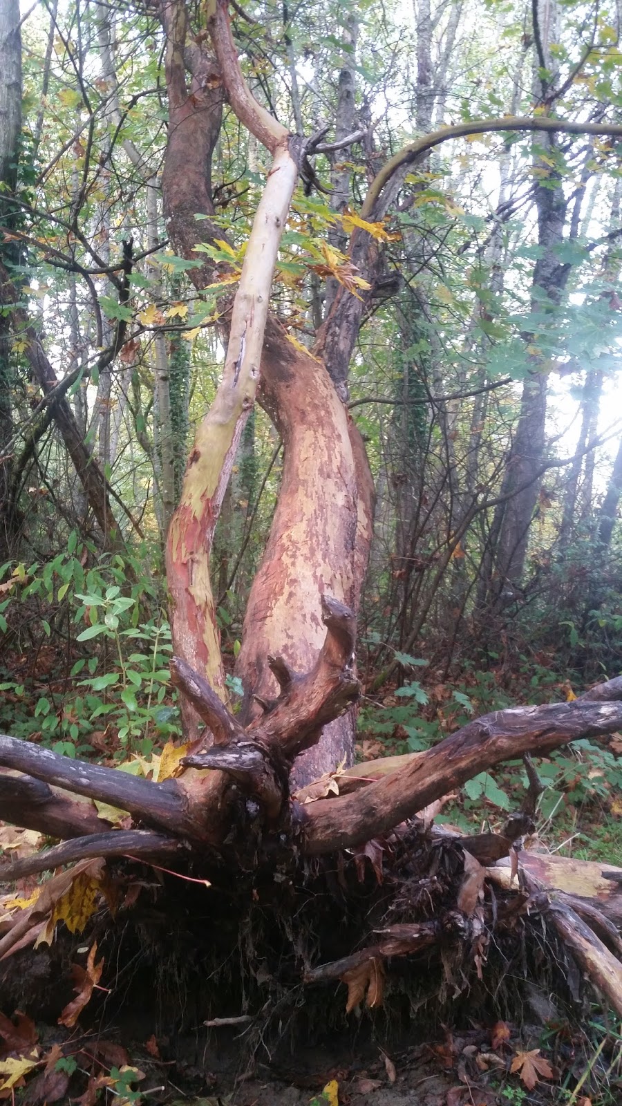
Walk on the main trail for about 70 feet and then veer right off the path into the forest. Continue south through the thicket of tall ferns and you’ll
find yourself on a ledge overlooking a steep dip in elevation with a similar
view on the opposite side. This is a ravine. Flowing through the lowest part of
the ravine is a small stream. Ravines are formed from stream-cutting erosion,
which is evident is this case as water still runs through here. The elevated
sides of the ravine are much higher than the water level, suggesting that at
one point the stream came up about 10-15 feet higher. The stream flows out into
a marsh that is connected with the ocean—so technically, the marsh can be
considered a small estuary, a body of water that serves as a transition zone
from fresh water to salt water. If you climb down by the stream, you’ll find
rounded rocks that are characteristic of stream deposits, as they’re constantly
churned through moving water. Interesting to note, there is another larger
ravine on the north side of the park. This likely suggests that from the west
running east, there was at one point a larger river channel that diverged on
either side of the park, forming these two ravines that parallel each other.
The other ravine currently has no running water draining out to the bay, which
is interesting since it is the larger of the two ravines, meaning at was at one
point the primary drainage channel of the two. I’m curious if, depending on the
season and year, the stream changes its path to the north ravine instead of the
south ravine it currently runs through.
  |
| Rounded rocks (left) are typical stream deposits. The stream (right) cuts through and erodes the axis of the ravine. |
Station #3: Ecological relationship (pink)
If you are standing overlooking the ravine, you should see a
huge Bigleaf Maple in front of you, on the opposite side. Its trunk is almost
completely covered in green. Ferns, ivy, lichen, moss and fungi all blanket the
bark. Many of these hitchhikers are epiphytes, or plants that grow off other
plants without harming the host. According to the University of Puget Sound’s
Slater Museum of Natural History, Bigleaf Maple is known to “[support] more epiphytes
than any other tree in the region.” How are epiphytes like moss and Licorice
fern able to survive without soil nutrients? They take nutrients and moisture
from the surrounding air instead. Thus, they can only survive in high-moisture
areas like the Puget Sound. Over time, they can even accumulate fallen debris
to create their own soil in which they can create root systems—off the side of
a tree! (Slater Museum of Natural History.) Licorice ferns, which grow
exclusively as epiphytes and are seen in the picture, are named for their
licorice-flavored rhizomes. Not all that grows on this tree is harmless. The
English Ivy that creeps up the trunk is an invasive species that outcompetes
native plant species by growing around them and starving them of light and
nutrients. As a well-established tree, this maple will probably not be phased
by the ivy invasion, but other less sturdy plants find it difficult to survive
in competition with the ivy.
 |
| Licorice fern and epiphytic moss growing on a Big Leaf Maple. |
Station #4: Fungi (yellow)
Return back to the main trail and continue for about 100 feet. Then, go back off the trail into the forest to the right. You'll have to trek for a bit until you get near the stream (the same one from Station #2,) but once you get there you'll find a decomposing stump housing some cool fungi. It's hard to miss. These fungi are different than the usual gilled mushrooms we're familiar with--they have teeth on the underside! Fungi is important for aiding in decomposition, so seeing fungi on dead trees like this one is very common. Mycorrhizal fungi will also attach themselves to the roots of trees and provide specific nutrients for them as the trees provide different nutrients to the fungi. Both parties mutually benefit from the interaction, making it a symbiotic relationship. In this area, fungi grows mostly in the fall when moisture levels are high. This is just one of the many cool fungi species you can find here at Dumas Bay Sanctuary. Others include Artist's Conk and some species of coral fungi. It takes a real exploratory spirit to find the cool ones, as oftentimes, they grow in inconspicuous places. Nonetheless, fungi is awesome and there is a large variety of things you can find, so it’s worth exploring to find some interesting things.


Interesting fungi that can be found growing off the side of a dying stump.
Station #5: Birds (purple)
For this station, I recommend binoculars. Return to the main
trail and continue straight through, making your way to Brewer’s bench. The bench is located off the main trail in
the center of an open area with a lone cluster of Red Alder trees behind it.
Here, on a nice day, you are likely to see a flock of American Robins. Robins
prefer these open areas for foraging for insects in the soil, but also need to
use the forested areas for nesting. The open/dense contrast here is a typical
habitat for American Robins. If you look around the grassy open area around the
bench, you’re likely to find other ground foragers such as Song Sparrows and
Dark-Eyed Juncos. There is an abundance of (very territorial) Song Sparrows in
this forest, so if you hear a repetitive and agitated squeak, look for an
aggressive Song Sparrow. They are brown and white with brown stripes on the
breast, so they may be a little hard to find in the brown of the forest. If
there happens to be a flock of Black-Capped Chickadees near (listen for the chicka dee-dee-dee-dee-dee alarm call,)
you are likely to find other birds flocking with them, having figured out that
flocking together means a greater chance of survival. Of these species is the
very cute Golden-Crowned Kinglet. They are similar in size to the chickadees,
but will have a gray body with a distinctive yellow patch on the head
along with a black eye stripe. I've also seen a beautiful hairy woodpecker around here, so listen for drumming. Be sure to check back at different times of year
to find birds that are here in the winter but not the summer, and vice versa!  |
| American Robin |
 |
| The bench I'm referring to. "Brewer's Bench" is engraved in it. |

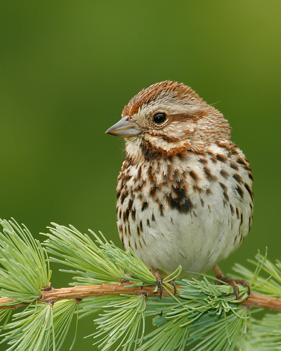
Golden crowned kinglet (left) and song sparrow (right)
Source (kinglet picture): http://www.larkwire.com/library/bird-sounds/1451/Golden-crowned-Kinglet-songs-and-calls
Source: (robin picture): https://www.allaboutbirds.org/guide/American_Robin/id
Source: (song sparrow picture): http://www.tringa.org/image/9097_Song_Sparrow_06-02-2007_3
Station #6: Plants (orange)
This
site is close. In fact, it’s right in front of you. Shift your focus from the
birds and look at the tall Red Alders growing in a cluster behind the bench.
They are the most abundant tree species in this forest. But, why? If you dig
around in the soil a little bit, you’ll see that the soil is surprisingly sandy
and poor. It’s hard to fathom how such a soil is capable of providing nutrients
to these tall trees, and how the trees appear so healthy given the soil. The
answer lies in a cool evolutionary adaption of Red Alder: nitrogen fixation. Nitrogen,
essential to vegetation growth, is abundant in the atmosphere, but sometimes
scarce in soil. Root nodules in alder can fix atmospheric nitrogen and bring it
into the soil, helping the alder to survive but also facilitating the growth of
other species by enriching the soil with nitrogen. Alders are a pioneer species
that can thrive in sub-par soils that other trees cannot survive in. This
adaption is one of the key reasons why Red alders were the first trees to
colonize the Puget Sound area after glaciation, a time when the soil, having
been under a colossal heap of ice for so long, was almost completely devoid of
nutrients.


Red alder bark & leaves.
Station #7: Ecological Disturbance (white)
For this station, walk out into the open area to the other bench. There is a trail next to the bench that leads northwest up the hill. Follow this trail. About 20 feet after the hill levels out, you’ll see a huge uprooted Pacific Madrone to your right. Pacific Madrones have a flower-like leaf arrangement and peeling bark, revealing a smooth inner layer. Even if you're not familiar with the tree species, you really can’t miss it; the roots are practically in your face. What’s interesting is that some of the roots are still strongly fixed in the ground, so the tree continues to survive despite being nearly on it's side. Other trees in the area are fallen, and branches are strewn all around on the forest floor or resting in shrubs. I figure the only thing that could have caused this is the wind. The sandy soil plays a role in this widespread windfall—it’s not thick or cohesive enough to hold the roots of these trees securely in the ground. Recurrent windy conditions eventually lead to adaptions within tree species, such as "shorter, thicker and, therefore less slender, trunks and branches which better resist deflection, and improve root anchorage" (Oxford Journals.)
 |
| The uprooted Pacific Madrone. |
Station #8: Invertebrates (green)
Past the madrone, you'll see a skinny, fallen, decomposing log to the left. I brought you to this log only because it is pretty big
and many invertebrates may be resting under there, but really any large log
will do. Move the log over and you will likely find a variety of bugs. Of these
there may be beetles, pill bugs, slugs, ants, spiders, and other invertebrates. These are only some of the things I found during late fall, but I can only imagine what kind of cool stuff will be here during the spring and summer! As you move the log, some loose pieces of bark may fall off naturally. Make
sure to check under these, as many bugs like to hang out in the spaces between
the bark and tree. You will have better luck and more fun looking for
invertebrates during the warmer times of year, when there is an abundance of
insects in a wider variety. During the winter, most are hibernating and you
will find less variety. Nonetheless, it’s still interesting to see what remains in
the colder times of year. That being said, be mindful of uncovering their
habitat, as it may be vital to their survival for hibernation purposes. Replace
the logs back where you found them. |
| Slug on a nurse log. |
 |
| Common name: "Common black ground beetle." Many species fall under this common name. |
Station #9: Herons (silver)
Make your way back down to the main trail and continue
towards the beach, looking up in the trees for nests. When you reach the beach, you'll see a marsh area to the right. Dumas Bay Sanctuary is
home to one of the largest Great Blue Heron breeding colonies in this area.
Look for these large, elegant, gray birds with an elongated neck and long, sharp bill. They are the largest species of heron, and can reach a length of 4.5 feet with a wingspan of 6.6 feet (National Geographic.) All birds have hollow bones to aid in flying, so although these herons are large, they are not very heavy. You’re most likely to see them in the spring when they come here to breed, but
since Great Blue Herons are found in the Puget Sound area year-round, you may
get lucky and see some here during the winter months. You’re likely to find
them in the marsh hunting for prey.
They will creep along very slowly through the water, and when they catch sight
of prey (usually fish or small mammals,) they will use their dagger-like bill
to stab their prey with alarming speed. You can also find their nests built high in the canopy of trees near the beach. Keep your eyes peeled for herons in flight, too.
Their long neck retracts during flight to increase aerodynamics and conserve energy. 

Great Blue Heron and marsh area
Source (picture): http://fail-avenger.deviantart.com/art/Great-Blue-Heron-349861287
Source (Heron info): http://animals.nationalgeographic.com/animals/birds/great-blue-heron/
Station #10: Animal Behavior (brown)
Now, on to our final stop. While out on the nice, sandy
beach, you’ll find many rocks and washed up logs. I’m sure that during your
trips to the beach as a kid, you would turn over rocks to uncover little crabs.
Such gallant little spirits, scurrying to either side with their claws thrown
up pugnaciously, taunting you as if to say “I could take you on,” despite the
fact that we are at least a thousand times bigger than they are. Well, now’s
the time to relive your childhood adventures—only now, with a bit of natural
history knowledge. Most of these crabs you find under the rocks are Purple
Shore Crabs (Hemigrapsus Nudus.) As
the name suggests, the crabs are “usually purple but vary to reddish brown or even olive
or yellow; younger ones are even more variable” (Slater Museum of Natural
History.) Purple Shore Crabs are found all the way along the west coast of
North America and beyond; ranging from Southern Alaska to northern Mexico.
These crabs feed mostly on algae and burrow under rocks with others. They are
often eaten by fish and gulls. If you spend enough time here, you may be able
to find gulls hunting for crabs in the sand, and witness the workings of the
food chain in action. Who needs to watch a lion hunting a gazelle on the Nat
Geo channel when you can go outside and watch the same concept right before
your eyes? It takes more patience and observation, but is much more rewarding! |
| Purple Shore Crab. Note the purple spots on the claws. |
I was just at Dumas Bay Natural Area a few days ago. I saw my first merlin there. Really nice place!
ReplyDeleteI was very happy to stumble upon this post. I took scouts to the Dumas Bay Sanctuary and we followed your nature hike. We had to skip Stations 2 and 3. There was no clear path and the off-trail areas are very overgrown now. We follow Leave No Trace and I didn't want them stomping through the ferns. We did look at the big leaf maple from the trail and used binoculars. Pretty much everything else is still there as you wrote about it in 2015. Great post and thanks!
ReplyDelete